This guide is intended to help anyone interested in bouldering in the Dedza area. In my explorations in this area I’ve found a lot of good rock, but a whole lot more not-so-good rock, and because most people won’t have a whole month to spend in Dedza, hopefully this will highlight just the good stuff. There are about 85 problems that I’ve found that are worth doing—note that I didn’t climb a few of the routes that either were harder than V5, had sketchy landings without a crash pad, or were longer than 20’, so their ratings won’t be accurate and there may be loose rock. On the other ones, I’ve done basic cleaning—removing lichens from key holds, pulling off holds and flakes that are on routes and don’t hold body weight, and uprooting thornbushes and other plants at the bases of the routes. That said, this is still a pretty wild area. Some of the landings are harsh and I’ve tried to note those problems in the specific route descriptions. Other routes have trees growing at the base, so five or ten years from now the routes might not exist.
The format of the guide book is as follows. I’ll give the lat-long-elev of the different bouldering areas according to my best estimates using Google Earth. There is one hand-drawn map to assist that is not to scale. Rocks on the maps that are colored black have routes worth doing; blue ones are boulders that can be useful for reference but don’t have routes covered here. Note that not all rocks within the boundaries of the map are drawn on the map. Each rock with any routes worth doing will also have a picture or two, with any routes indicated by a red dotted arrow that begins at the starting footholds and ends at the top handholds. Large traverses will be noted in text, but I’ll avoid offering beta or describing individual moves or holds. My best estimate of the route rating and length is provided, with anything below V0 using the Yosemite Decimal Scale. Note that I’m 6’3” and a lot of these grades are height-dependent. For any route that I did not climb, the grade will be prefaced with a “~”. A lot of the routes are very close to each other, but for the most part the routes don’t share holds, so they are distinct. I have avoided naming any of the rocks or the routes except where it made references a lot easier.
The Boulder Garden
The Boulder Garden is located at 14° 22’19.93″ S, 34° 18’34.65 E, elevation 5207′. It is about a quarter of a mile west of the intersection between the Dedza Mountain Road (road from town that goes up to a plateau west of the mountain, and up to the south summit where the radio towers are), and an unnamed road that contours the base of a minor summit on the southwest flank of Dedza Mountain, at about 5200’ in elevation. That road ultimately forks into several footpaths that lead to various places along the Dedza Pottery Road (see map), near the lumber mill. The rocks shown are all to the northeast of the large molar tooth-shaped rock visible from the M1, and pretty much everywhere in Dedza.
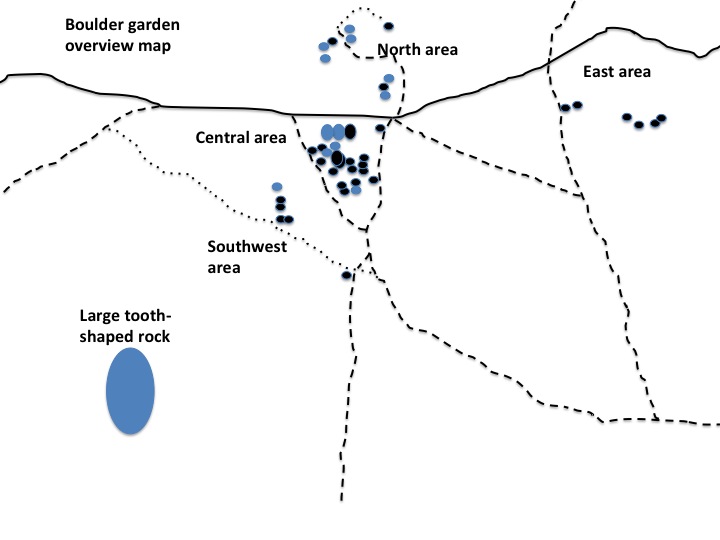
The area covered by this map can be accessed from a number of different trails; the most effective way I can describe the approach is just to find trails from the Dedza Pottery Road or from the unnamed dirt roads just east of the Dedza Pottery Road that head towards the large molar tooth, and then go northeast of that. Or take the Dedza Mountain Road from town and make the turn-off to the left before climbing up the mountain. Note that in the wet season some of the trails that come from the south or southeast lead through marshes.
1: 5.7, 25’. Descend to the left.
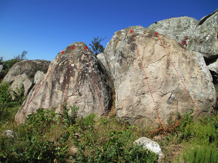
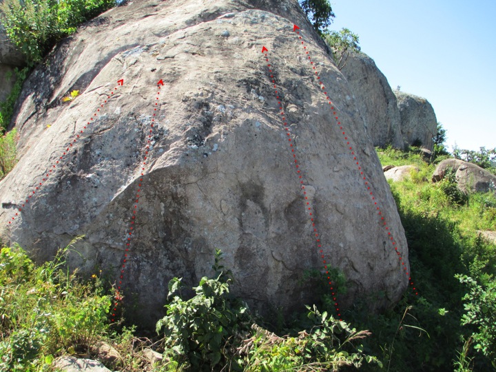
This is a large south-facing boulder whose north side is adjacent to the road.
1: 12′ V2 2: 14′ V2 3: 15′ V0 4: 12′ V1 5: 10′ V2/3
The northeastern-most rock in this area, close to the intersection of the 5200’ road and the trail that bounds the east side of the area. Northeast aspect shown. Easy descent, good landings.
1: 12′ V3. 2: 12′ V0.
Next to the trail at the eastern edge of the Boulder Garden. Southeast aspect shown. Easy descent to the back side; good landings.
The two left-most boulders in a group of three about 50’ west of the last one. East aspect shown. Easy descent to left. Landings are OK.
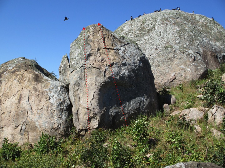
1: 18′ V4. 2: 18′ V4.
Immediately right of the last one. Descent to the right (about 5.7). Landings are at an angle.
11’ V1.
Immediately behind the last. Easy descent.
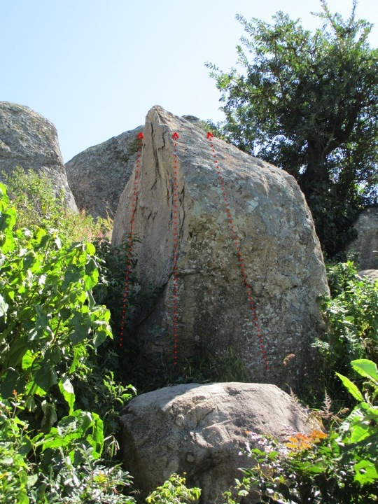
1: 13′ V1. 2: 15′ V4. 3: 13′ V3. 4: 13′ V2.
These are the same rock, from the south (left panel) and from the east (right panel). Recommended to do the V1 first because this is the descent route. The V4 has a rock at the landing; landings on other routes are good.
1: 12′ V1. 2: 12′ V2. 3: 14′ ~V4 (top 4′ would need to be scrubbed).
The face on this boulder has a west aspect. The boulder is 30’ downhill and southwest of the last. Bad landings on the two right-most problems (onto a perched boulder). Easy descent.
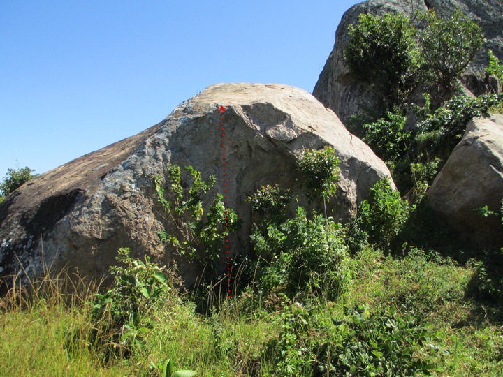
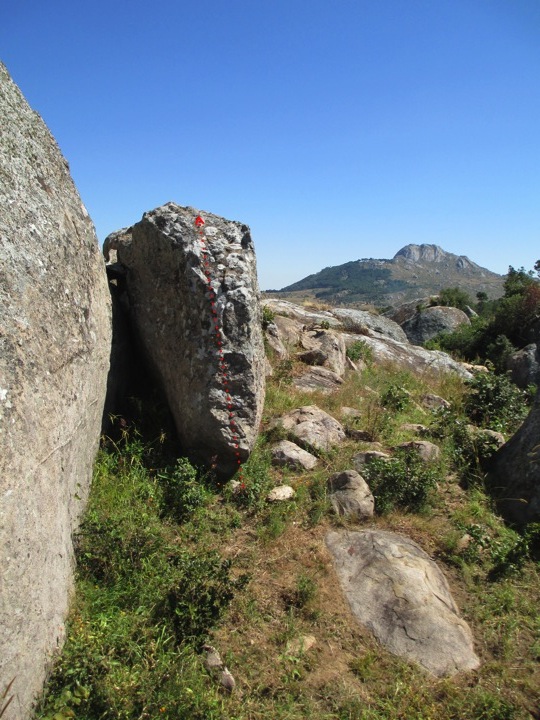
11’ V0.
This route is between two trees that might get big some day.
This south-facing boulder is about 20’ west of the last, and is the southern-most in the group. Easy descent, landings may be shared with trees.
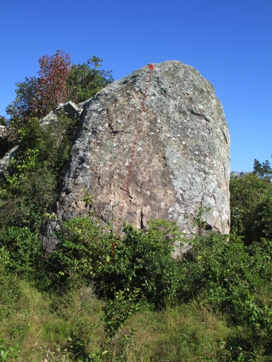
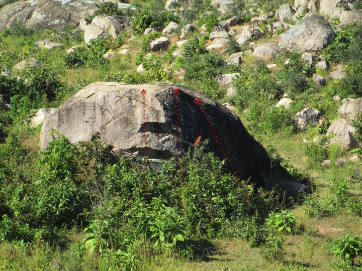
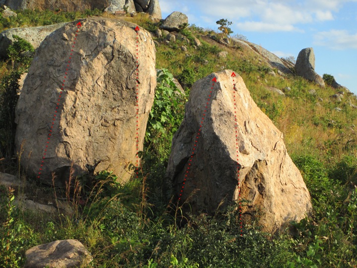
1: 30′ ~5.11. 2: 30′ ~5.10.
This is the northwest face of the northern-most of the three large rocks at the center of the boulder garden. The routes may be too high to be bouldered even with a crash pad, but the face is quite alluring, especially at sunset when the size of the holds is illuminated. Descent to the southeast.
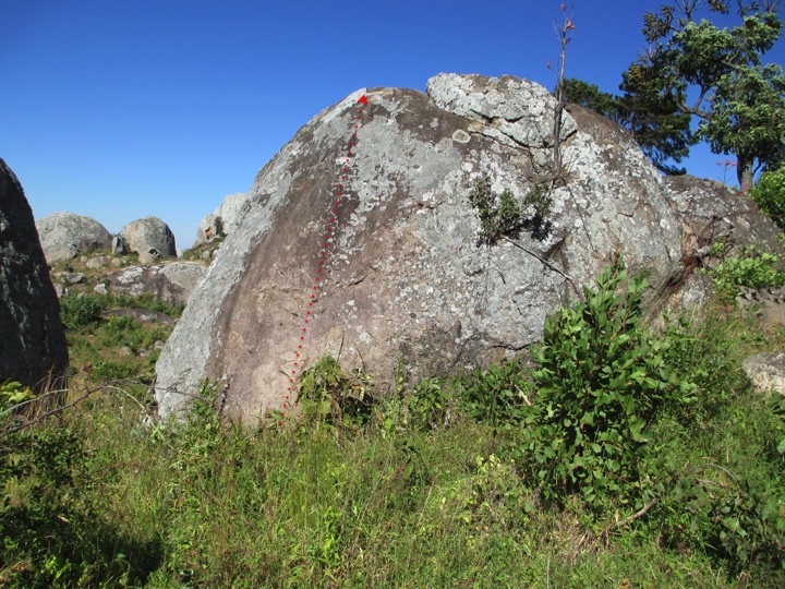
18’ V1.
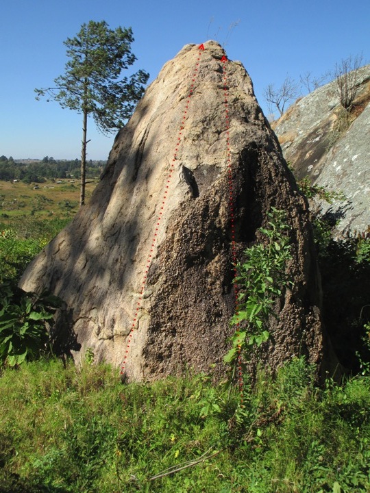
This is the east face of the northernmost of the three large boulders at the center of the garden. It is a reasonably clean, well-featured, less than vertical face with a slightly mossy top-out. The descent is down the left arête from this view. The landings are fine but the route is slabby.
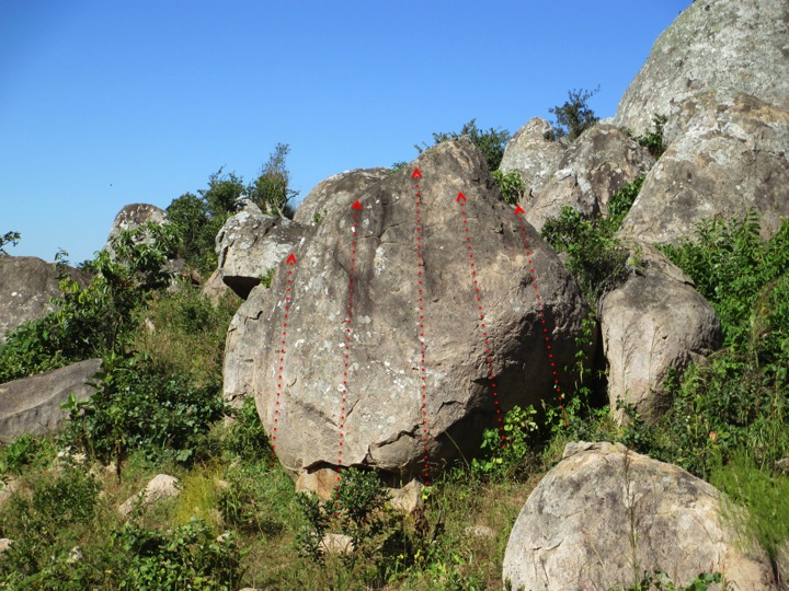
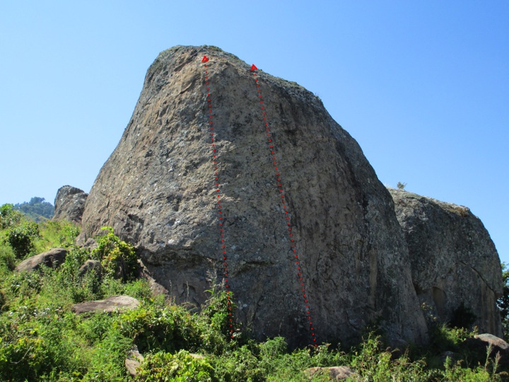
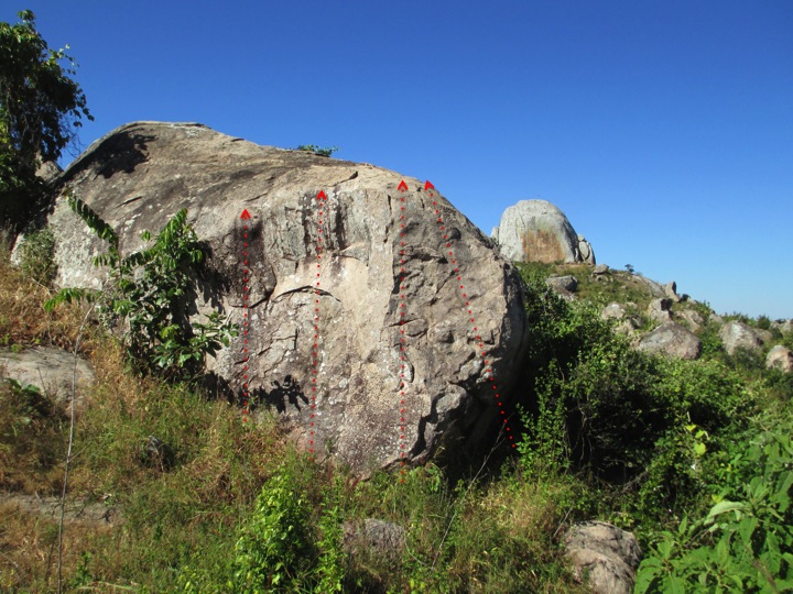
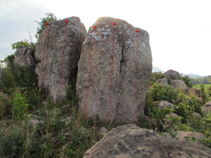
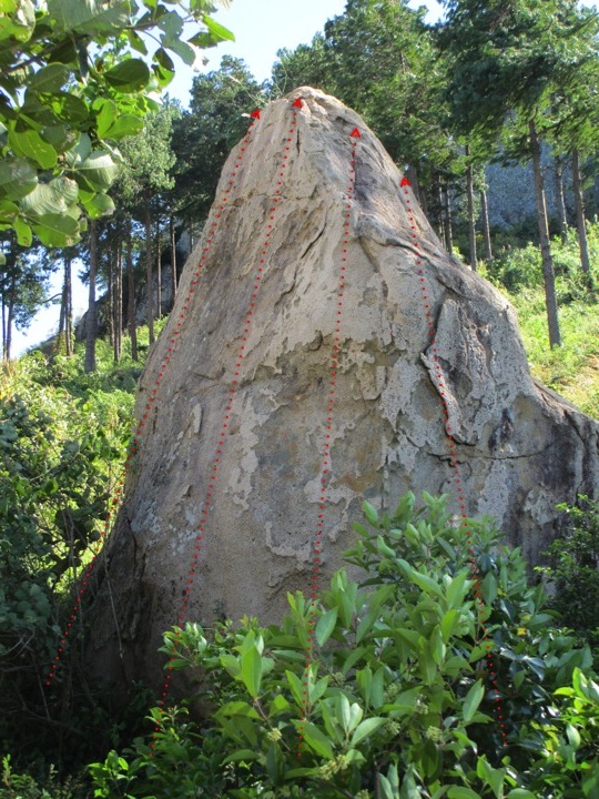
1: 12′ V0. 2: 12′ ~V5. 3: 15′ V3. 4: 18′ V5.
This west-facing boulder is just downhill and west of the last. 5.3 descent to the left. Landings OK.
1: 15′ V1. 2: 15′ V2. 3: 15′ 5.5 slab.
This is northwest aspect of a boulder that is right next to the trail that cuts through the western side of the garden (visible to the right in the picture). Only slightly better than it looks. Easy descent to the south. Landings involve trees.
1: 12′ V2. 2: 12′ V2. 3: 12′ V2. 4: 12′ V3.
This north-facing boulder is about 50’ east of the last, and about 150’ to the west and facing the opposite direction of the first problem listed here. Easy descent, easy landings.
The Boulder Garden, Southwest Area
The rocks in this section are just to the southwest of the main area, still to the northeast of the main molar tooth visible from far away.
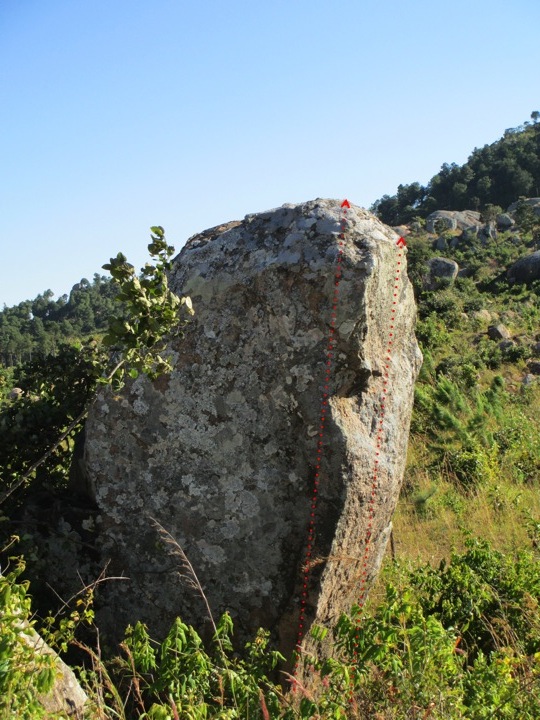
1: 12′ ~V5 2: 14′ ~V6
These two routes are located on a thumb-shaped rock south of the main area of the boulder garden, on the southwest corner of a trail junction. The landing is less than ideal, particularly without a crash pad (on an angled rock just out of the picture). Easy descent down the back side.
1: 12′ V0 2: 12′ V0 3: 12′ V0. 4: 12′ V1. 5: 12′ V2. 6 (around to R): 12′ V3
These are also located to the southwest of main area, and are about 200’ northwest of the last boulder. This is from southeast; the last route listed is just to the right. Farther to the right is loose flakes. Descent to the northwest; landings easy.
1: 12′ V0- 2: 12′ V3 3: 9-V1 4: 11′ V3.
These are located 15’ to the north of the last. Watch for loose holds on the second one. The fourth problem has a nice sit start. Descent on the left rock is to the left; on the right it is easy down the back side. Landings are OK except for the second problem where the landing might involve the right-most boulder.
The Boulder Garden, North Area
The rocks in this section are located on a hill above the dirt road that contours at 5200′. They are ordered according to when you encounter them walking up the hill on the trail that comes out of the main trail junction between the 5200 road and the trails to Dedza Pottery and the main paved loop road. The second rock is at the top of the trail, next to a shelter. To get to the third rock, continue off-trail up the ridge from here (walking east), dropping down about 30′ after 100′ of walking, and the rock will be visible to the right.
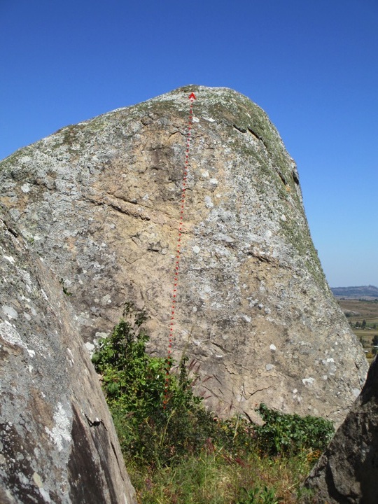
13′ V1.
About 50’ up the trail from the road and on the left, between several other boulders. This route goes up the only clean face around. Easy descent to right; easy landings
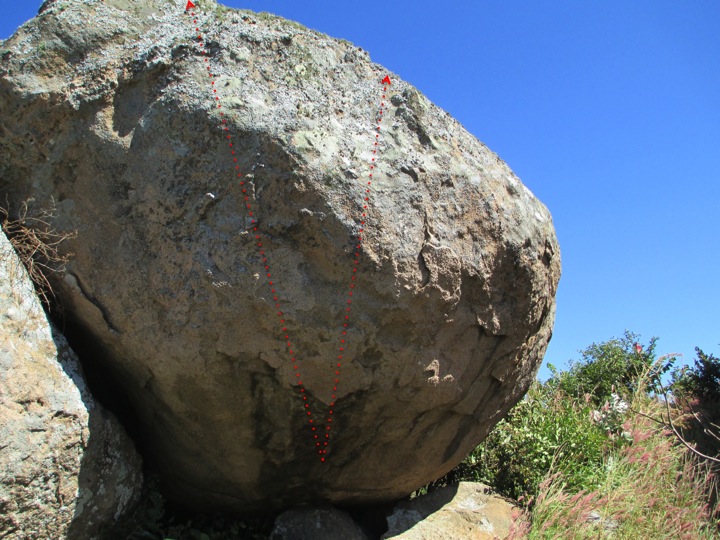
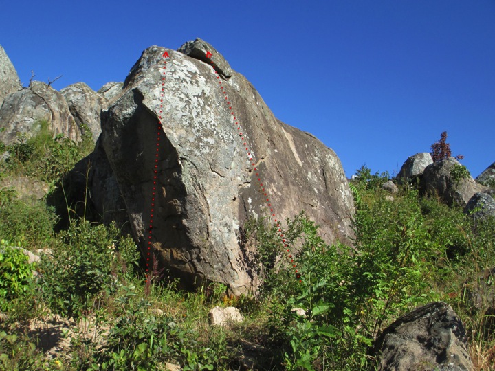
1: 15′ ~V10 2: 15′ ~V8.
The Buddha of Dedza. This is located on the trail described above, at the top of the hill, just before the remains of an old shelter. The top-outs on each of these routes are covered in moss and lichens and would need to be cleaned. Easy descent/access to the top via the back side. Landings are fine.
1: 12′ V0 2: 12′ V1
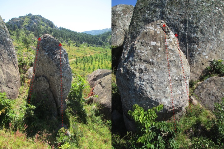
This nice-looking rock is about 250′ to the east of the last, in a small valley. This is the view from the northeast; descent is the left (southeast) arete pictured here (~5.3).
1: 13′ V1 2: 13′ V1 3: 13′ V3 4: 13′ V3.
Same rock as before, but from the southwest. The right-most route has a flake that may be loose.